

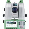
Leica Nova MS60 1′ R2000 MULTISTATION Robotic Total Station
When you are out in the field, you need a fast and versatile instrument. Leica Nova MS60 is the worlds first MultiStation, helping you perform all required surveying tasks with just one instrument. The MS60 can be used as a total station without any compromise and offers the option to scan with a speed of up 30,000 points per second. Benefit from digital imaging and GNSS connectivity. Master your projects by performing point cloud analysis directly in the field such as flatness analysis or as-built checks in the Inspect Surface app and by automatically measuring your instrument height with the AutoHeight feature. Seamlessly transfer your data with Leica Exchange into Leica Infinity to manage, process, analyse and quality check it.
LEICA NOVA MS60 MULTISTATION: MASTER YOUR PROJECTS WITH THE ULTIMATE ALL-ROUNDER
– Surfaces and volumes in construction and mining: spoil heaps and stock piles, DTM creation and checking surfaces, material thickness, blast faces and ground levels.
– Analysis of complex structures and objects within plant, marine and utility projects: dimensional control, as-built and record keeping.
– Measuring buildings and structures: bridge condition/clearance analysis, BIM and as-built.
– Faç,ade, elevations and heritage work: creation of traditional faç,ade deliverables, 3D models and photographic documentation.
– Traditional topographic surveys for surveying and mapping: creation of traditional deliverables like 2D maps or 3D models.
– Enhanced prism monitoring with scanning: 24/7 automatic mm-level measurements of surfaces like roads, buildings, dams and tunnels with real-time messages in case of detected movements.
The new version of Leica Nova MS60, the worlds first MultiStation, enables you to perform all surveying tasks with one instrument. It brings sensor fusion to the next level by combining:
Highest-end total station
Highly accurate angle and distance measurements, long-lasting design and easy-to-use apps are key elements of modern total stations, fully embodied in the MS60. With improved automation functionalities using ATRplus, the MultiStation
increases your efficiency, even under challenging environmental conditions.
GNSS connectivity
GNSS is fully integrated in the workflow and the data structure, enabling direct georeferencing. SmartStation and SmartPole setups increase your flexibility in the field.
3D laser scanning
Scan with up to 30.000 points per second (Hz): complete your scans fast and get dense scanning grids. The MS60 features optimised scanning paths, now including zenith scans, allowing you to significantly reduce the total scanning time.
Digital Imaging
Enhanced digital imaging technology, including an overview and a 30x magnifying telescope camera, enables accurate image assisted surveying both at the instrument and remotely – while also including extended image documentation.
WORLDS FIRST MULTISTATION
– 3D data capture by precise long-range scanning (up to 1,000m)
– 1,000 pts/s up to 300 m- Millimetre scan precision
WORLDS FIRST SELF-LEARNING MULTISTATION
– Automatically and continuously adapts for best measurement performance to site conditions, such as rain, fog, dust, sun, heat shimmer, and reflections
– Identifies and ignores irrelevant targets and reflections
ATRplus WITH DOMINANT PERFORMANCE
– Automated target aiming range up to 1,500 m
– Automated target locking range up to 1,000 m
– Accelerated target search with PowerSearch
– Robust and highly-accurate position delivery in high-dynamic applications
PINPOINT R2000 DISTANCE MEASUREMENT
– Single EDM for highest accuracy and wide range at the same time
– Visible measurement beam of small spot size
– Measurement range on any surface beyond 2,000 m
– Fastest measurement times
HIGH RESOLUTION DUAL CAMERA IMAGE SYSTEM
– 5 megapixel telescope and overview camera
– Video frame rate of up to 20 Hz onboard and remote
– Automatic focusing
Additional information
| Brand | Leica |
|---|
Reviews
There are no reviews yet.